7-Day Machame Route Trek Overview
Tour Overview
Price Start From $1850 Per Person, 2 Pax
Mount Kilimanjaro – Uhuru Peak (5,895 m / 19,341 ft)
Route: Machame (Ascent) – Mweka (Descent)
Overview
The 7-day Machame Route is one of the most balanced and successful itineraries on Mount Kilimanjaro, combining dramatic scenery, excellent acclimatization, and a carefully staged ascent profile. Often referred to as the “Whiskey Route,” Machame is more challenging than some alternatives but rewards trekkers with constant landscape variation and strong summit success rates. Extending the route to seven days allows for improved altitude adaptation, reduced daily exertion, and a safer, more comfortable summit attempt.
The route ascends through dense montane forest, across the Shira Plateau, and into high alpine desert before reaching the arctic summit zone. Descent is made via the Mweka Route, providing a logical and efficient return to lower elevations.
After an early breakfast, you depart Arusha for a scenic drive to Machame Gate, passing through cultivated farmland and local villages before reaching the rainforest zone of Kilimanjaro National Park. Upon arrival, park formalities are completed and the trekking crew prepares loads for ascent. The trail begins immediately within dense montane forest, where humidity is high and the ground can be muddy and slippery, especially after rain. The path follows a steady ridge, gaining elevation gradually and allowing trekkers to establish a sustainable pace. This first day is designed to introduce the body to altitude without excessive strain. Machame Camp is reached in the late afternoon, located near the upper boundary of the forest where temperatures begin to cool significantly at night.
Elevation: 1,830 m (6,000 ft) → 3,050 m (9,950 ft)
Distance: 11 km (7 miles)
Hiking Time: 5–6 hours
Habitat: Montane Forest
Meals: Lunch & Dinner (Breakfast not included)
Accommodation: Budget Camping
Leaving the forest behind, the trail climbs steeply along a rocky ridge as vegetation gradually thins and the environment becomes more open. The transition from rainforest to moorland is marked by cooler air and expansive views as the route crosses a river gorge and continues westward. Giant heathers and volcanic rock formations dominate the landscape. As you approach the Shira Plateau, the terrain levels out, revealing a vast volcanic caldera formed by Kilimanjaro’s ancient eruptions. The day’s steady ascent allows for continued acclimatization, and the afternoon at Shira Camp offers time to rest, hydrate, and observe the dramatic change in scenery.
Elevation: 3,050 m (9,950 ft) → 3,850 m (12,600 ft)
Distance: 5 km (3 miles)
Walking Time: 4–5 hours
Habitat: Moorland
Meals: Breakfast, Lunch & Dinner
Accommodation: Budget Camping
This day is critical for acclimatization and overall summit success. The route heads east across the Shira Plateau toward Kibo Peak, gradually gaining altitude through increasingly barren terrain. The ascent to Lava Tower also known as the “Shark’s Tooth” exposes trekkers to significantly higher elevation, where the air is thinner and exertion feels more pronounced. After lunch near Lava Tower, the route descends sharply into the Barranco Valley. Although the overnight elevation is similar to the previous night, the high-altitude exposure earlier in the day triggers physiological adaptation, strengthening the body’s ability to cope with altitude. Barranco Camp is set in a sheltered valley beneath towering cliffs and glaciers, offering one of the most scenic campsites on the mountain.
Elevation: 3,850 m (12,600 ft) → 4,650 m (15,250 ft) → 4,000 m (13,000 ft)
Distance: 10 km (6 miles)
Walking Time: 5–6 hours
Habitat: Semi-desert
Meals: Breakfast, Lunch & Dinner
Accommodation: Budget Camping
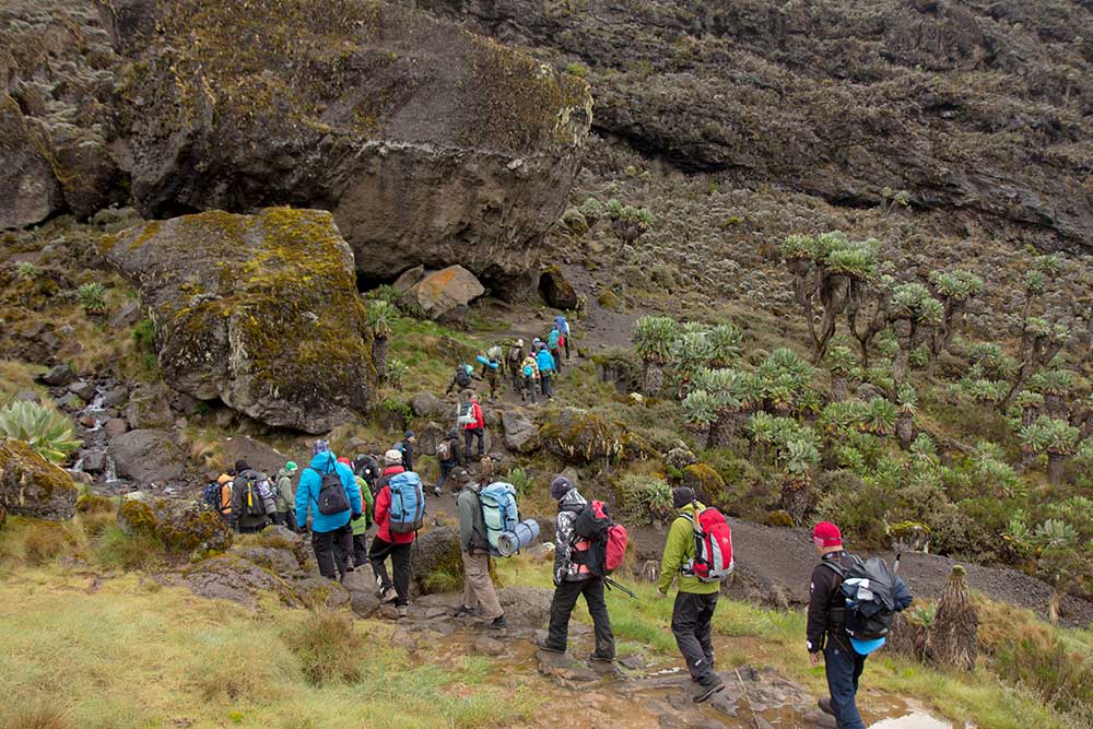
The day begins with the ascent of the famous Barranco Wall, a steep but non-technical scramble that requires careful movement and occasional use of hands. Although visually intimidating, the climb is well managed by guides and offers spectacular views once completed. Beyond the wall, the trail traverses exposed ridges and valleys, with a series of short ascents and descents that further support acclimatization. The surrounding landscape is stark and dramatic, with sweeping views of glaciers and the southern slopes of Kilimanjaro. Karanga Camp is reached by early afternoon, allowing time for rest and recovery in preparation for higher elevations.
Elevation: 4,000 m (13,000 ft) → 4,050 m (13,250 ft)
Distance: 5 km (3 miles)
Hiking Time: 3–4 hours
Habitat: Alpine Desert
Meals: Breakfast, Lunch & Dinner
Accommodation: Budget Camping
The day begins with a steady climb towards Barafu Camp, marking the completion of the South Circuit. From here, you'll enjoy panoramic views of Mount Kilimanjaro from various angles. Take some time to rest, have a hearty dinner, and prepare mentally and physically for the summit ascent that begins very early the next morning.
- Elevation: 4,050m (13,250ft) to 4,700m (15,350ft)
- Distance: 4km (2 miles)
- Climbing Time: 3-4 hours
- Habitat: Alpine Desert
- Meals: Breakfast, Lunch & Dinner
- Accommodation: Budget Camping
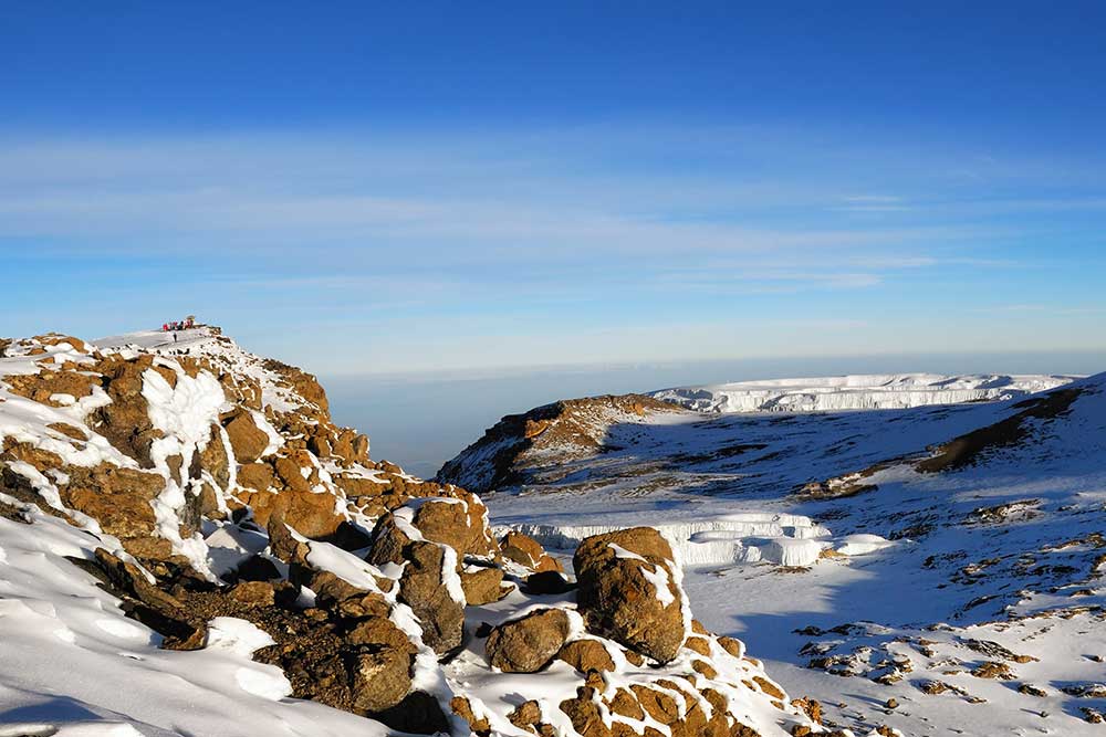
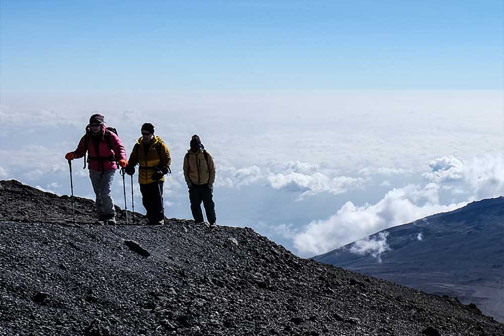
Summit day begins between midnight and 2:00 a.m. under cold, windy conditions. The ascent follows a steep trail over loose scree toward Stella Point on the crater rim, demanding sustained effort and mental focus. Oxygen levels at this altitude are roughly half of those at sea level, making pacing and breathing control critical. From Stella Point, the route continues along the crater rim to Uhuru Peak, the highest point in Africa. After a brief celebration at the summit, descent begins immediately, returning to Barafu Camp for a short rest before continuing down to Mweka Camp. The drop in altitude brings noticeable relief, though fatigue from the long day is significant.
Main Destination: Mount Kilimanjaro
Accommodation: Budget Camping
Meals: Breakfast & Lunch (Dinner not included)
Drinks: Drinking water only
Note: Longest and most physically demanding day of the trek
The final day involves a steady descent through dense montane forest. The trail can be wet and muddy, requiring careful footing and the use of trekking poles. As altitude decreases, temperatures rise and vegetation becomes lush once again. Upon reaching Mweka Gate, park formalities are completed and summit certificates are issued. A vehicle transfer returns you to Arusha, marking the conclusion of the expedition. The sense of accomplishment is heightened by the contrast between the summit’s arctic conditions and the warm lowlands below.
Elevation: 3,090 m (10,150 ft) → 1,680 m (5,500 ft)
Distance: 10 km (6 miles)
Hiking Time: 3–4 hours
Habitat: Forest
Meals: Breakfast & Lunch (Dinner not included)
Drinks: Mineral Drinking Water
Includes
- Camping equipment
- A professional mountain guide
- Professional chef
- Porter team
- Trekking poles
- First aid kit
- Emergency oxygen
- Rescue fees
- Portable toilet
- Park fees & entry fees
- All government taxes
Excludes
- Personal trekking gear
- Tips for mountain crew
- Travel insurance and visa fees
- International
- domestic flights
- Trekking poles
- Accommodation before and after the trek
INCLUSIONS:
- Full-board accommodation as specified
- All meals during the safari
- Transportation in a 4WD Land Cruiser with pop-up roof
- Professional English-speaking driver-guide
- All national park entry fees
- Bottled mineral water during the safari
EXCLUSIONS:
- International/domestic airfares and airport taxes
- Entry visas and vaccinations
- Personal items and expenses
- Laundry services
- Tips and gratuities for driver/guide
- Optional tours and excursions
- Travel insurance
Your dream Adventure starts here - how would you like to experience Tanzania?
24/7 HOUR AVAILABLE
+255 658 961 496